
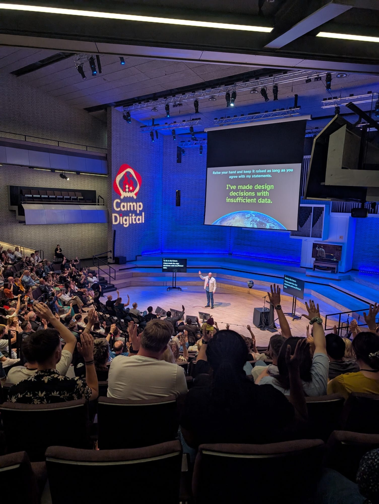
On the third of July I delivered the closing keynote at Camp Digital 2025, a conference at the Royal Northern College of Music in Manchester organized by Nexer Digital. This was a brand new talk I put together specifically for this event, and this is the companion page for the talk – for anyone looking for a recap or to completely nerd out.
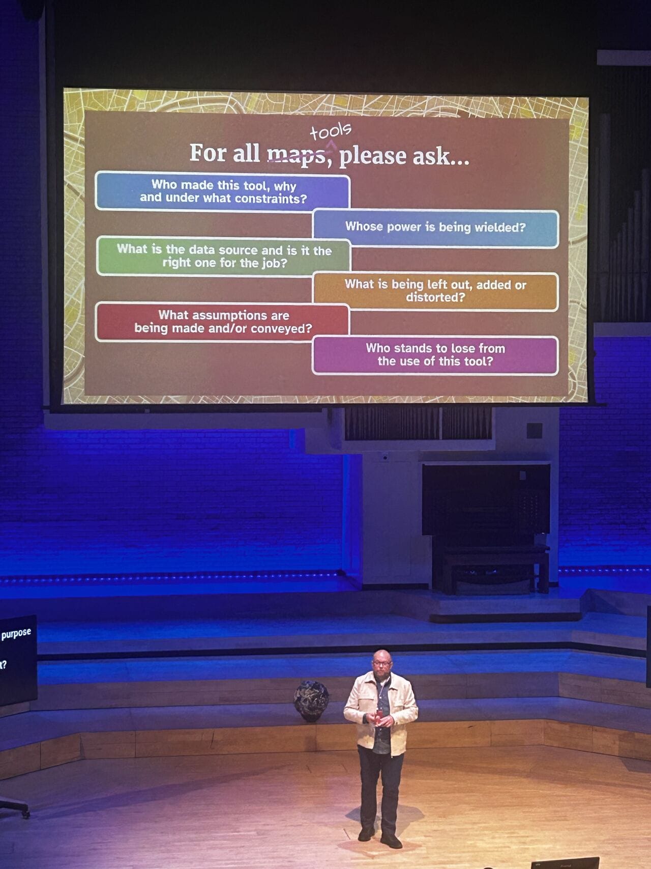
The premise is this: What you see in a map can never be the complete truth. Many choices are made in their making, based on intent, values, real-world constraints, bias and budget. I used the world map to bring home these points, highlighting how we deceive and are deceived, and emphasising the inherent responsibilities of designers.
Slide deck
Download
Browse
Videos in the talk
These were the videos embedded in my presentation. As there was a bit of sound trouble, you can enjoy them with sound here.
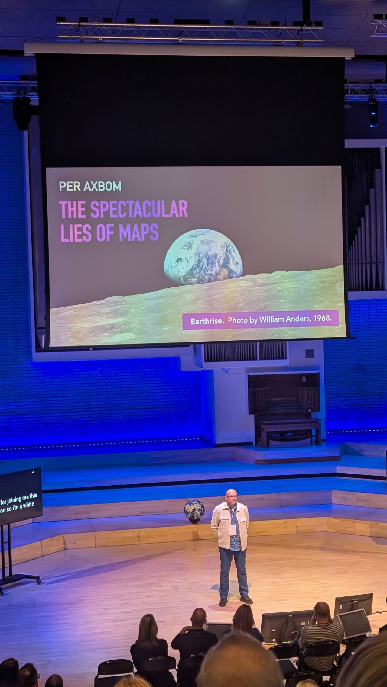
Earthrise reconstruction of photo moment (Source)
Imago Mundi 3D model
Hannah Fry peeling an orange. No sound on this one (Source)
Short, trimmed clip from West Wing season 2 episode 16.
This was the first time I delivered this talk and I'll likely do a write-up within a few months. Do subscribe to my newsletter for updates on this and more related to human rights in technology and design. And let me know if you're interested in having me present the talk at other venues.
Audience photos from the talk
If you have any high-resolution photos that you feel comfortable sharing with me, I'd really appreciate being able to use them on my website. You can send them to per@axbom.com.
Photos of Per speaking by James Winstone, Joanna Czutkowna, Megan L., Aleksandra Sielaff, May Viratikul & Becky Colley.
Reactions
"I won’t trust maps from today. I will peel an orange and try flattening it out. I know it won’t work 🍊"
– Nataliya Mykhalchenko
"Per Axbom’s talk on maps […] was incredibly intriguing."
– May Viratikul
"For Per Axbom to then return to our lovely community event after a few years, and calmly blow our minds in such a scholarly but weirdly accessible way topped off a day of double-takes for me."
– Hilary Stephenson
"What an absolute treat it was to hear from Per Axbom on the nonsense that is trying to map a sphere and the weird, wonderful, and sometimes worrisome consequences of mapping the world."
– Megan L.
"I thought Per Axbom's session on the spectacular lies of maps was the perfect way to end the day, with something interesting, a little different, that still made you think - in this case, about how any representative illustration and design you might do is inherently going to distort the truth. But there are ways to minimise that, and ways to ensure the audience understands the trade off."
– Amanda Tribble
"Per Axbom’s closing keynote holds a special place in my map-loving heart 💕🌍 it was a real treat to learn so much from him."
– Eleanor Hamed
Links and references
Video source material
- NASA Earthrise: The 45th Anniversary. Recreating the moment when the crew first saw and photographed the Earth rising from behind the Moon (youtube.com)
- Clip from The West Wing season 2 episode 16. CJ Clegg hosts the Organization of Cartographers for Social Equality. (vimeo.com)
- A Strange Map Projection (Euler Spiral). Hannah Fry talks about map projections and peels an orange. (youtube.com)
- Google Earth clip of the longest distance you can travel in a straight line across water (vimeo.com)
- Use Literally Anything but Web Mercator (youtube.com)
References
- Why “Earthrise” is the Most Influential Photo Ever Taken (and why it matters just as much now as it did in 1968) (linkedin.com)
- Earthrise: The Photo that sparked an environmental movement (ansarsblog.com)
- Imago Mundi: The Oldest Known Map (thearchaeologist.org)
- Defining the Term “Middle East” (pressbooks.pub)
- Bluesky thread with examples of maps using different perspectives (bsky.app)
- The route of Emirates flight EK225, Dubai to San Francisco. (brilliantmaps.com)
- Mercator projection (wikipedia.org)
- The True Size of…, a tool for comparings country sizes on the Mercator projection (thetruesize.com)
- Map comparing the size of Russia to the size of Africa using the Mercator projection (reddit.com)
- Corrected version of the "size of Russia and Africa using Mercator projection" map (reddit.com)
- Top 10 World Map Projections (futuremaps.com)
- Directory of Map Projections (mapthematics.com)
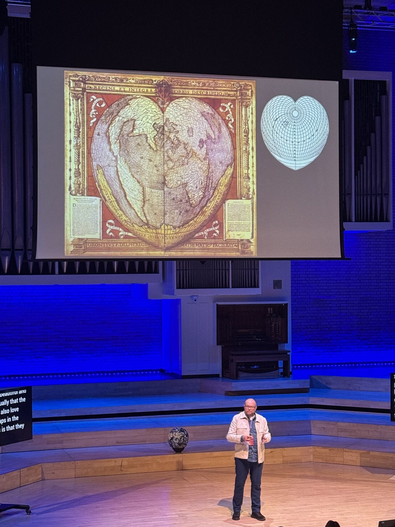
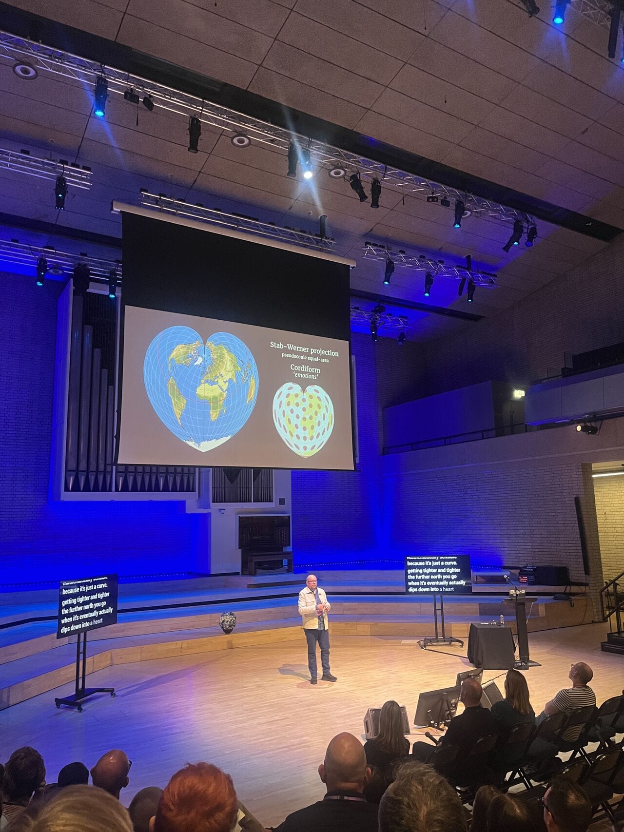
- Cordiform: Heart-Shaped Map Projections (geographyrealm.com)
- Authagraph map projection (authagraph.com)
- Catherine Reeves' Equinational Projection (bigthink.com)
- Valeriepieris circle (wikipedia.org)
- Map of Australia resembles Scooby Doo (bsu-earthview.blogspot.com)
- The Google Maps / Bing Maps Spherical Mercator Projection (alastaira.wordpress.com)
- The effects of using Web Mercator projection instead of the Mercator projection for representing Romania on maps (sgem.org)
- Implications of Web Mercator and Its Use in Online Mapping (researchgate.net)
- Web Mercator and comparisons (cartonerd.blogspot.com)
- What is the current Web Mercator projection code? (gis.stackechange.com)
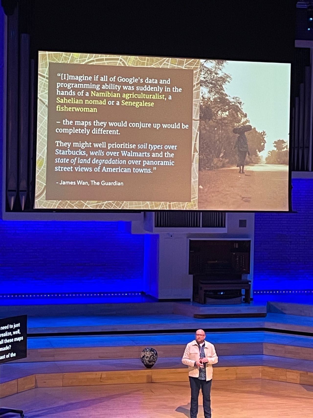
- Why Google Maps gets Africa wrong (theguardian.com)
Photos
Unless otherwise specified, photos are from Freepik.com where I have a paid subscription. I always select photos that are marked as not AI-generated.
- Earthrise, photo by William Anders remastered by Jim Weigang (scitechdaily.com)
Further reading and watching if you can't get enough
- The essential lies in news maps (datajournalism.com)
- Lying with maps (umn.edu)
- Misled by maps: How data visualisation shapes our stories (geoversity.io)
- The Places We Lost in Maps, by Alastair Somerville (acuity.design)
- Cartography: Africa and revisiting the world map (modernghana.com)
- 99% Inivisible podcast: Maps, They Don’t Love You like I Love You (99percentinvisible.org) – A podcast with Rebecca Solnit, Author of “Infinite City: A San Francisco Atlas”.
- An Equal-area Projection in the Fashion of the AuthaGraph Map (blog.map-projections.net)
- Heart-shaped projection of the Earth (cam.ac.uk)
- Making sense of the world one map at a time (brilliantmaps.com)
- The secrets of the AuthaGraph revealed! (kunimune.blog)
- How the world would look without oceans (youtube.com)
- Swedish visual artist Nikolaj Jesper Cyon: "I made, more than 10 years ago (2010-2011), my first map of a Africa that could have been, if it had not affected by colonialism because, I was always curious about what civilisation, wonders and cultures surely must have existed there but were not taught in the history lessons in the Swedish school systems."
- Asking ChatGPT to generate a map of Europe, Maria Sukhareva on LinkedIn (linkedin.com)
Podcasts

Books

Five book covers: Mapmatics, A History of the World in 47 borders, Prisoners of Geography, The Phantom Atlas, How to Lie with Maps